TRAQUA is a spin-off from the University of Namur. The first model of the STREAM® fluorometer was developed in 2015 by Amaël Poulain and Geert De Sadelaer, as part of Amaël Poulain’s Ph.D. thesis in karstic hydrogeology. The project required field fluorometers to characterize underground water flows in the karst systems. The team quickly realized that the fluorometers available on the market were too cumbersome, specifically in hard-to-reach sites such as karst caves. After several years of development, testing, and field experiments, Amaël decided to create the company TRAQUA to offer the expertise and innovative fluorometers to actors in the water field, with the aim to make this type of analysis and monitoring more accessible for the management and protection of water resources.
New paper in Journal of Applied Geophysics
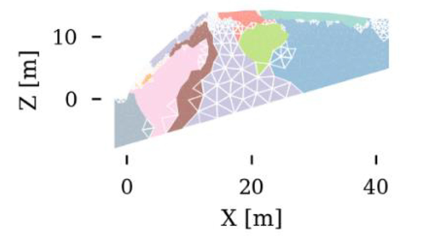
Delforge, D., Watlet, A., Kaufmann, O., Van Camp, M., Vanclooster, M., “Time-series clustering approaches for subsurface zonation and hydrofacies detection using a real time-lapse electrical resistivity dataset”, Journal of Applied Geophysics (2020). 10.1016/j.jappgeo.2020.104203.
This article studies how to analyse automatically the numerous data series resulting from the measurements of the variations in the electrical resistivities of the soil on the site of the Lorette Cave (Rochefort). These variations, which inform us about the modifications of the water content of the subsoil, were described in their hydrogeological context by A. Watlet ( Watlet, A., Kaufmann, O., Triantafyllou, A., Poulain, A., Chambers, J., Meldrum, P., Wilkinson, P., Hallet, V., Quinif, Y., Van Ruymbeke, M., Van Camp, M., Imaging groundwater infiltration dynamics in the karst vadose zone with long-term ERT monitoring, Hydrology and Earth System Sciences (2018). 10.5194/hess-22-1563-2018).
New paper in Water Resources Research
New paper evidencing unknown voids within the Lorette karst system, evidenced by the continuous gravity measurements of flash floods. This was first achieved with a gPhone spring gravimeter in 2013, continued with a superconducting gravimeter since end 2014.
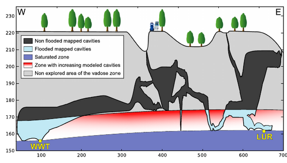
Watlet A., Van Camp M., Francis O., Poulain A., Rochez G., Hallet V., Quinif Y., Kaufmann O., Gravity monitoring of underground flash flood events to study their impact on groundwater recharge and the distribution of karst voids, Water Resources Research, doi:10.1029/2019WR026673, 2020.
New paper in WRR
A new paper is published by our PhD student Damien Delforge (ULouvain & ROB), who investigates the non-linear baseflow of the Lhomme River upstream and downstream Rochefort:
Delforge D., Vanclooster M., Van Camp M., Muñoz-Carpena R., A parsimonious empirical approach to streamflow recession analysis and forecasting, Water Resources Res., doi:10.1029/2019WR025771, 2020.
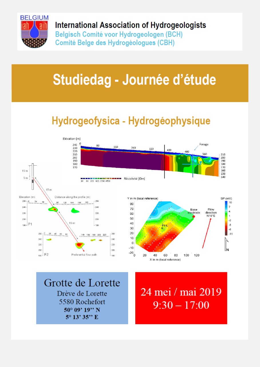
Study day 2019 “Hydrogeophysics”
On Friday May, 24, 2019, the Belgian Chapter of the International Association of Hydrogeologists organised its study day at the Rochefort-Lorette site. After an academic session in the morning, the participants visited the Rochefort Laboratory.
EGU meeting: about the non-linear interactions in a karst system
Hydrological connectivity from causal analysis of time series in the Lhomme Karst System, Belgium.
EGU meeting, Vienna, April 8, 2019
The hydrological behaviour of karstic systems is difficult to theorize holistically because of their specific heterogeneities leading to distinctive non-linear processes. Karstified systems present great opportunities for field exploration and hydrogeological monitoring of the vadose zone through its network of caves and conduits. These unique but explorable environments are predisposed to an inductive scientific approach where transfer processes associated with hydrological connections are directly inferred from the data. This is done conventionally using dye tracing from which connections and transfer times are undeniably revealed. However, single tests do not allow appreciating the dynamic character of the hydrological connections. Nowadays,several data analysis methods aim at the detection of causal relationships between time series allowing the investigation of dynamics and interactions. Some are designed for linear systems as the simple cross-correlation method or the Granger causality, while others are suitable for non-linear interactions, such as the Convergent Cross Mapping method. Here, these methods are applied in order to draw up causal maps and compare short-term (up to 2 days) interactions in the Lhomme Karst System in Belgium. The Lhomme Karst System has been monitored since 2013 and many time series are available: meteorological data, soil moisture, drip discharges in the caves, piezometric levels, and local gravimetric time series. In addition, dye tracing experiments revealing connections and characteristic transfer times were conducted. The different causal maps are compared and causal interactions are appreciated through the current knowledge of the system and discussed in relation to the question: can we infer true hydrological connections and processes from the empirical determination of causal relationships between hydrological time series?
9 November: PhD thesis of Arnaud Watlet
On 9 November 2017, Arnaud Watlet will defend his PhD thesis dedicated to the de FNRS KARAG project of Rochefort.
Arnaud will present 4 years of results on the saturated and non-saturated zones of the karst aquifers.
The jury will be composed of the following members:
Supervisors:
Prof. Olivier Kaufman, Université de Mons
Dr. Michel Van Camp, Observatoire Royal de Belgique
Jury:
Pr Jean-Marc Baele, Université de Mons
Pr Thierry Camelbeeck, Observatoire Royal de Belgique
Pr Konstantinos Chalikakis, Université d’Avignon
Pr Cédric Champollion, Université de Montpellier
Pr Olivier Francis, Université de Luxembourg
Pr Pascal Goderniaux, Université de Mons
The dissertation defense will take place at 15 pm at U. Mons, Salle Académique, Bd Dolez, 31 (2e étage), 7000 Mons. The defense is public.

PhD thesis of Amaël Poulain
Congratulations to Amaël on his PhD degree obtained on 6 September!
Rochefort Cave lab on TV
The underground work of the KARAG team was presented on Belgium national televion (La Une) 28th of September at 12:40 PM! The small documentary focuses on the Rochefort cave laboratory and the measurements made in the vadose zone of the Givetian karst aquifer (click on the picture to watch the video).
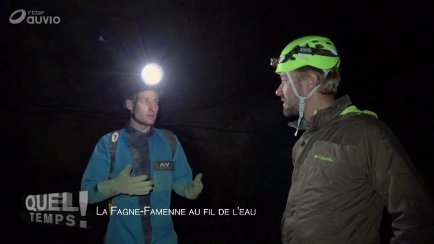
Don’t miss this opportunity to discover our work 😉
A first PhD for KARAG
Amaël Poulain presented his PhD thesis last week, in the framework of the KARAG project.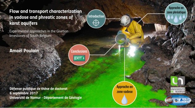
Follow this link to see the Prezi presentation : https://prezi.com/view/KK6w99xScFwkSzY8t7ln/
The thesis file may be downloaded at the following URL : https://documents.unamur.be/index.php/s/NyWlXUuYjK8exeW
Remember that Arnaud Watlet will also present his PhD thesis in Geophysics this year. Stay tuned for more information !