All posts by Michel Van Camp

A new Ph.D. student for KARAG

02 January 2017:

A new Ph.D. student joints the KARAG team: Ir. Damien Delforge. The supervisors are Prof. Marnik Vanclooster (UCL, Earth and Life Institute/Environmental Sciences (ELI-e)) and Dr. Michel Van Camp (Royal Observatory of Belgium, Seismology-Gravimetry). This project is supported by the Fund for Scientific Research FNRS-FRIA.

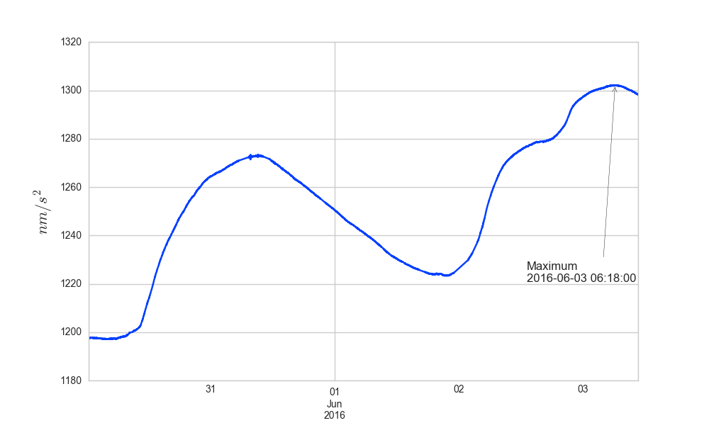
The objective of the project is to improve gravity signal processing and karst systems modelling through the use of novel data mining techniques, derived from chaos theory, known as convergent cross mapping (CCM). CCM is a statistical method to elucidate cause-effect relationships between multiple time series that seek to resolve the problem that correlation does not imply causation. Regarding the uniqueness and the complex non-linear dynamics of karst systems, the main underlying assumptions are the following: (i) data-driven tools derived from the chaos theory and CCM appears to be relevant to investigate both the relationship between the gravimetric signal and the monitored environmental variables and the hydrological behaviour of a karst system; (ii) using CCM analysis, a framework can be built to assess the realism of a hydrological model structure in complex hydrologic systems such as karst systems; and (iii) the resulting model structure can lead to a better prediction in water storage changes (WSC) and therefore to a better interpretation of the gravity signal.

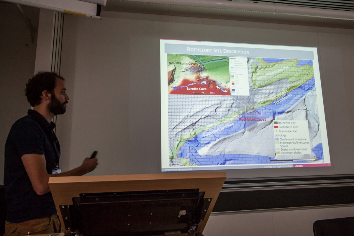
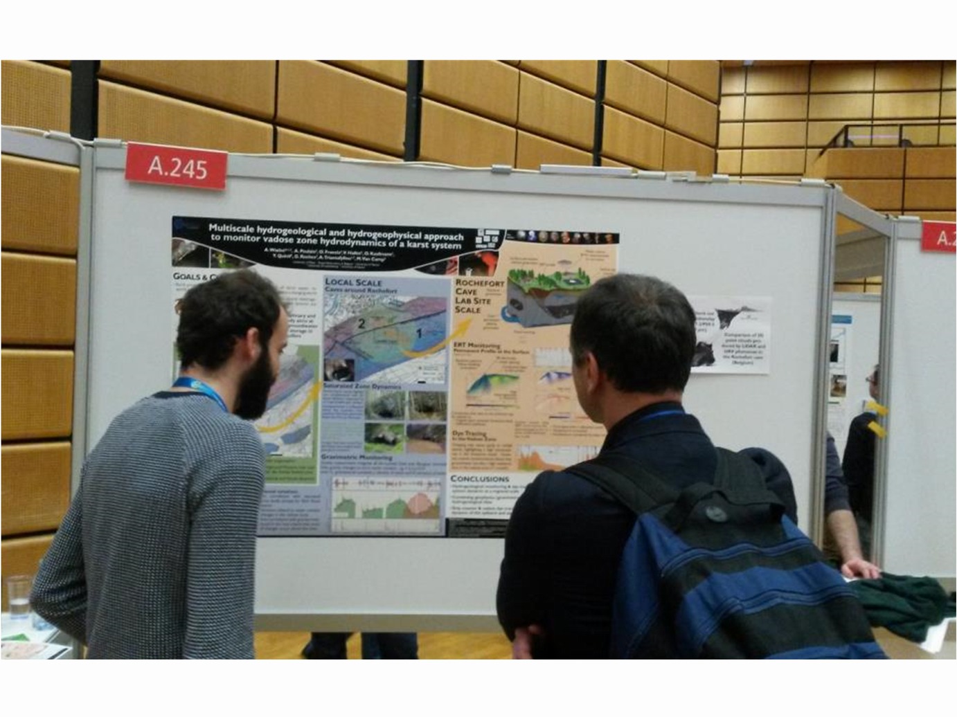
Based on this assumptions, this research aims at applying advanced causal analysis to  characterize the relationships between gravity signals and the locally monitored environmental variables and to assess what are the dominant hydrological processes involved in a complex Lomme karst system.

KARAG at the AGU Fall meeting 2016, San Francisco

  • Watlet, A., Kaufmann, O., Van Camp M., Triantafyllou, A., Fadel Cisse, M., Quinif, Y., P. Meldrum, P.B. Wilkinson, J.E. Chambers, Electrical Resistivity Tomography monitoring reveals groundwater storage in a karst vadose zone, AGU Fall meeting (poster), 12-16 Dec 2016.
  • Van Camp M., Watlet, A., Poulain, A., Hallet, V., Rochez, G., Quinif, Y., Meus, P., Kaufmann, O., Francis O., Continuous gravimetric monitoring as an integrative tool for exploring hydrological processes in the Lomme Karst System (Belgium), AGU Fall meeting (poster), 12-16 Dec 2016.

Eurokarst 2016

Arnaud Watlet proudly presents the latest results from the Rochefort Cave Laboratory at the 2016 Eurokarst meeting, Neuchâtel (CH), September 5. (picture: (c) Eurokarst 2016)
In particular, he comments on the gravity measurements, electric tomography profiles and hydrogeological investigations performed by the Royal Observatory of Belgium, U. Mons and U. Namur.

Arnaud Watlet presenting on September 5 at the Eurokarst 2016 workshop. Picture (c) Eurokarst 2016

Abstract:

Present knowledge of karst systems has evidenced the importance of the vadose zone on the water dynamics. Temporary perched aquifers can appear in the subsurface, especially in the epikarst layer, due to changes of weather conditions, reduced evapotranspiration and the vertical gradients of porosity and permeability. Seasonal water variations in the infiltration zone of a karst system should then be observable with geophysical techniques. Monitoring these variations may help separate the hydrological signature of the vadose zone from that of the saturated zone.

Although many difficulties are usually encountered when studying karst environments due to their heterogeneities, cave systems offer an outstanding opportunity to investigate vadose zone from the inside. We present results covering two years of hydrogeological and geophysical monitoring at the Rochefort Cave Laboratory (RCL), located in the Variscan fold-and-thrust belt (Belgium), a region that shows many karstic networks within Devonian limestone units.

Hydrogeological data such as flows and levels monitoring or tracer tests performed in both vadose and saturated zones bring valuable information on the hydrological context of the studied area. Combining those results with geophysical measurements allows validating and imaging them with more integrative techniques.

A microgravimetric monitoring involves a superconducting gravimeter continuously measuring at the surface of the RCL. Early in 2015, a second relative gravimeter was installed in the underlying cave system located 35 meters below the surface. This set up allows highlighting vadose gravity changes. These relative measurements are calibrated using an absolute gravimeter. 12 additional stations (7 at the surface, 5 in the cave) are monitored on a monthly basis by a spring gravimeter.

To complete these gravimetric measurements, the site has been equipped with a permanent Electrical Resistivity Tomography (ERT) monitoring system comprising an uncommon array of surface, borehole and cave electrodes. Although such an unconventional ERT setup is challenging in terms of data processing and interpretation, it provides valuable data for inferring variations of the vadose zone saturation rate


KARAG at the European Geophysical Union Meeting 2016

Arnaud Watlet proudly presenting the latest results at the EGU meeting (Vienna, 18-22 April 2016)

…and we are proud to announce that Arnaud was awarded at the “Outstanding Student Poster and PICO (OSPP) Award contest” at this EGU General Assembly 2016; see http://www.egu.eu/awards-medals/ospp-award/2016/

Redimensionnement de AW

1. Multi-scale hydrogeological and hydrogeophysical approach to monitor vadose zone hydrodynamics of a karst system
by Arnaud Watlet, Amaël Poulain, Michel Van Camp, Olivier Francis, Antoine Triantafyllou, Gaëtan Rochez, Vincent Hallet, and Olivier Kaufmann

2. Comparison of 3D point clouds produced by LIDAR and UAV photoscan in the Rochefort cave (Belgium)
by Arnaud Watlet, Antoine Triantafyllou, Olivier Kaufmann, and Stéphane Le Moueli

3. GeolOkit 1.0: a new Open Source, Cross-Platform software for geological data visualization in Google Earth environment
by Antoine Triantafyllou, Christophe Bastin, and Arnaud Watlet


The Earth is still ringing…

The Earth is still ringing… Note that the amplitude of this phenomenon is 10 times smaller than for the Boxing day 2004 Sumatra-Andaman earthquake (Mw=9.1-9.3, according to different estimates) and 2 times smaller than for the 2005 Nias earthquake (Mw=8.6).
Anyway, an amazing phenomenon.
0S0 is the so-called ‘breathing’ or ‘balloon’ mode; it involves radial motions of the entire Earth that alternate between expansion and contraction.

Chili_2015_1005

Membach 20-40

Logo Membach 20-40The big brother of the iGrav is the superconducting gravimeter GWR-C021 which was installed in Membach close to Eupen in August 1995.

This year this instrument will have been continuously measuring gravity changes for 20 years. This instrument allowed us to gain experience to make use of gravity measurements to investigate hydrogeological effects.

Concurrently, this year seismometers will have been measuring Earth vibrations for 40 years.

The Royal Observatory will celebrate this anniversary, together with the “Direction des Barrages” of the “Service Public de Wallonie”.

Among others, two workshops are organised:

Day 1: October 15, in La Gileppe: Scientific workshop in seismology « Earthquake activity and hazard in north western Europe », Dam of La Gileppe

Day 2: October 23, in Uccle (Brussels): Hydrology, Geophysics and Geodesy – HG², a new way to manage water resources », Royal Observatory of Belgium, Brussels

Superconducting gravimeter GWR-C021 of Membach